

















Coordinates are latitude, longitude in decimal degrees (WGS 84).

  1. 67.5058682411507, 12.078192006576986
  2. 67.51513468914455, 12.08493518828732
  3. 67.505804, 12.078177
  4. 67.5073590849653, 12.065177546083532
  5. 67.50935237711703, 12.084637338175526
  6. 67.5072785748648, 12.072763304188811
  7. 67.50584628839933, 12.077602087666037
  8. 67.505771, 12.07731
  9. 67.50612966053433, 12.074917466341276
  10. 67.51753216360989, 12.114710460726673
  11. 67.51502576627564, 12.099781326266452
  12. 67.51505322277606, 12.082958118237343
  13. 67.52692046439114, 12.134788805058633
  14. 67.48222028970501, 12.019300598732787
  15. 67.50991005034938, 12.110892708962865
  16. 67.50984986084315, 12.110492813758242
  17. 67.50960623233921, 12.109119129424357
  18. 67.50612966053433, 12.074917466341276
  19. 67.50877989943199, 12.082291183611119
  20. 67.51821718743378, 12.117007802757826
  21. 67.41091917675902, 11.875391820160075
  22. 67.50747567905728, 12.083485264227988
  23. 67.52603047616184, 12.116234813860393
  24. 67.50965570742511, 12.085232486232371
  25. 67.50577296093608, 12.077057237500298
  26. 67.50889100258605, 12.087050778985486
  27. 67.50910483874873, 12.088263145337805
  28. 67.505863, 12.072722
  29. 67.51778494222596, 12.11458943929938
  30. 67.505771, 12.07731
  31. 67.50912640995175, 12.08772709457594
  32. 67.51726788010984, 12.11567770245449
  33. 67.51791345482529, 12.115440285221894
  34. 67.511252, 12.083094
  35. 67.507714, 12.081874
  36. 67.50080053265681, 12.066739503161816
  37. 67.45048282343647, 11.911102435671523
  38. 67.520036, 12.132255
  39. 67.52902744666709, 12.127879941477193
  40. 67.51849821684506, 12.130003281418027
  41. 67.5071178091331, 12.069237539290157
  42. 67.52464956800205, 12.139828256617875
  43. 67.507636, 12.068234
  44. 67.48387735241747, 12.017714015599713
  45. 67.50738279813508, 12.083240342945007
  46. 67.5084730850169, 12.076840210316163
  47. 67.50838671719423, 12.077734199854604
  48. 67.5256, 12.134419
  49. 67.52193399694453, 12.139066008195858
  50. 67.526949, 12.127019
  51. 67.514288, 12.075469
  52. 67.50852249091419, 12.07791373200564
  53. 67.50943714405636, 12.109510948538968
  54. 67.524461, 12.10574
  55. 67.518296, 12.096267
  56. 67.50698295954241, 12.071960160079946
  57. 67.5172930024261, 12.115247615469684
  58. 67.51467221321533, 12.099594896243843
  59. 67.51741140631233, 12.11193323135376
  60. 67.51511350583986, 12.10016587363475
  61. 67.50835088360375, 12.07496526545674
  62. 67.52708349203935, 12.106192223194057
  63. 67.51759453780637, 12.118640550750229
  64. 67.5049239857241, 12.071401874529215
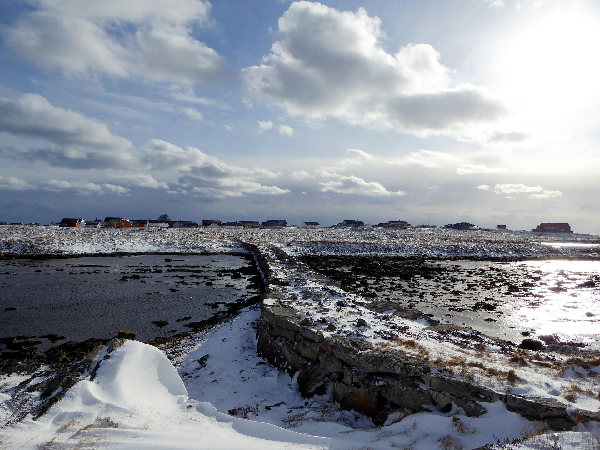
  • Tangspånga – a distinctive building

    © Foto: Elisabeth Johansen

Tangspånga – a distinctive building

Røst is made up of 365 grassy islands, the figure being more like 1900 if you include all the grey islets and reefs. The northernmost and largest island was previously called Hjemlandet (Home land).  It is around 2.5 km long and almost as wide.  It is today bound together with other islands by roads and embankments and is now called Røstlandet.  

Seven other islands were inhabited

A tale by pastor Svendsen states that seven other islands were also inhabited when he was there in the 1800s. These were Skomvær, Sandø, Glæa, Tyvsø, Kaarø, Lyngvær and Stensø. Stavøen and Storfjeldet, which were said to have been inhabited, were abandoned according to Svendsen.

https://en.wikipedia.org/wiki/Røstlandet

Innumerable small lakes and sea inlets

Svendsen claims that even though Røst is flat, it is not easy get around.  There were previously only poorly marked paths and you had to ‘navigate by using the location of the houses, orientation or even a compass.’ Other obstacles, he says, were the innumerable small lakes and sea inlets which blocked the way. To the great pleasure and as a sign of Røst’s progress, all on the island had ‘in recent years laid out an excellent path from one end of the island to the other.’

Hand built stone structures

If you move away from the asphalted roads, you can find traces of the time when Røst islanders fought against these obstacles and made roads.  There are a number of places where there were waves in inlets and where Røst islanders have built what they call ‘spenger’.  A spong, several spenger, in the local dialect.  These are impressive hand built stone structures which bind the land together.

The old road

One large and wonderful spong is Tangsponga between Brasen/Ystnes and Klakken.  This is the old road to Ystnes. Tangsponga is the largest stone spong on Røst. The year it was built is unknown. It is, however, undoubtedly from before 1900 according the cultural relic plan of the municipality. There are also remains of older boat landings and small quays in the area alongside Tangsponga.  The area north west of the spong has probably been one of the approaches to the oldest known church on Røst for those who lived in Storfjellet.


Original text: Elisabeth Johansen / John Roald Pettersen: LOFOTEN – en kulturminneguide, Orkana 2018

Reference work:
Stamnes, Einar: Kulturminneplan for Røst 2017–2022. Røst kommune 2016
Svendsen, Reinert: Historiske efterretninger om Værøy og Røst av Reinert Svendsen, fhv. sogneprest til Værøy. Aschehoug 1916. Ny utgave Sentraltrykkeriet 1981

Translation to English: Alasdair Graham-Brown

Photo: Elisabeth Johansen